
T
oday, Yellow Walls is largely made up of residential areas. The first “modern” estate Ard Na Mara was built in 19631, although Castleview Park which fronts on to the Dublin road dates from the late 1920s.8
Both estates (and Oakleigh Court) are built on land that was once part of the 30 acre La Mancha estate. La Mancha house was destroyed by fire in 1926. The laneway into Ard Na Mara from the Dublin road follows the same route as the driveway that once led up to the house.2
A large part of Millview is built on the site of the old Kettle farmstead also called Millview which was demolished in 1971. The ‘Mill’ refers to the now demolished windmill that stood on Feltrim Hill to the south rather than the cotton mill which stood to the west.6
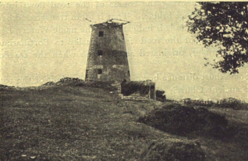
Feltrim Windmill
Building of houses in Seabury began in 1983.3 The familiar patchwork appearance of fields bordered by hedgerows upon which Seabury and other Yellow Walls’ estates are built (e.g. Millview, Ard Na Mara) is a result of ‘Enclosure Acts’ which were enacted by Parliament in the 1700s. These Acts encouraged the planting of hedgerows as a means of marking field boundaries.4 Prior to the enclosure acts, most land in Fingal was unenclosed commonage. These fields were largely used for farming activities.*
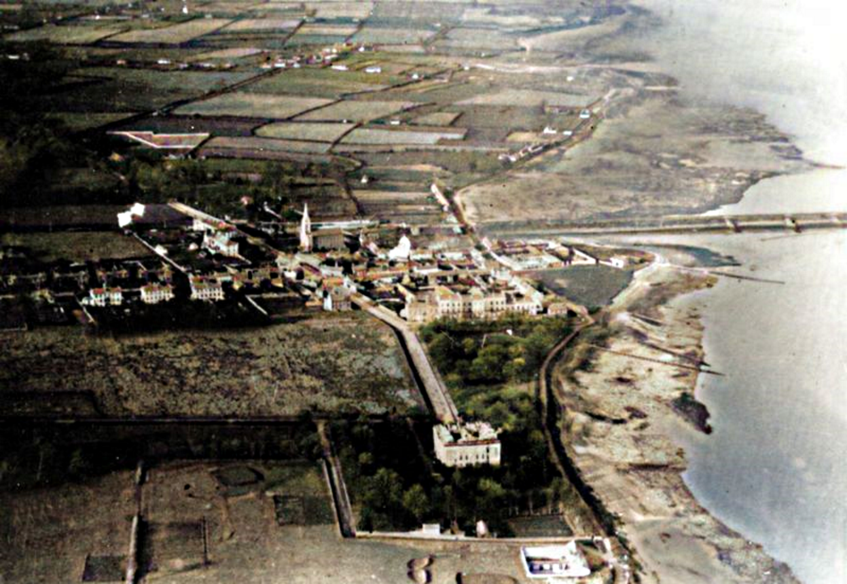
Aerial photograph of Malahide showing Yellow Walls (top half) as mostly farmland. The Grand Hotel, gardens adjoining The Mall/James’s Terrace, and outdoor swimming baths on Bath Lane are visible in the bottom half of the image. The walled feature to the top left of the image is the cemetery on Yellow Walls Road and in the distance can be seen Yellow Walls crossroads (Image colourised using DeOldify).
The newspaper advertisement9 below appeared just 4 years before Ard Na Mara was built and gives an insight into the character of the area at that time.
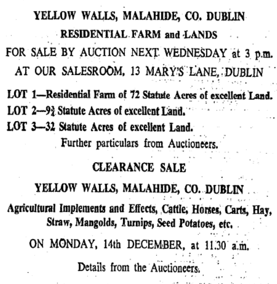
Newspaper notice from 1959 advertising the sale of farmland, agricultural implements, livestock and crops in Yellow Walls. © Irish Times.
Historical ordnance survey maps2† show that the farm lands of Seabury had extensive frontage onto the Broadmeadow Estuary at Old Yellow Walls Road. This is now Estuary Park, an 8-acre park with a children’s playground, playing pitches and exercise equipment.
Estuary Park
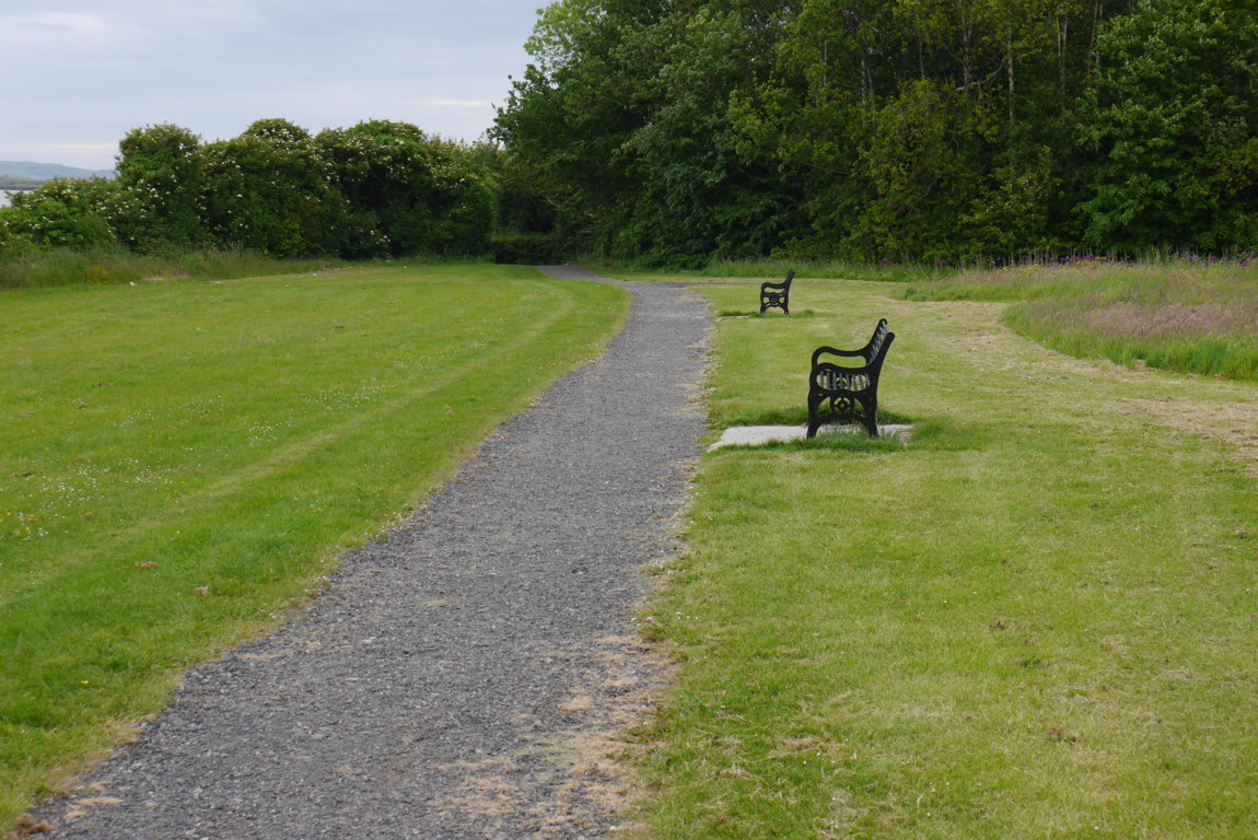
A pathway that runs around the park leads down to the waterfront before continuing on to Cave’s Marsh.

Pathway to Cave’s Marsh from Estuary Park
This pathway may eventually form part of a walking and cycle route around the entire Broadmeadow estuary.
The historic maps indicate a now demolished building fronting onto Old Yellow Walls road at Estuary Park. There is also a well marked on the opposite side of the park beside the route of the ‘Old Sea Road‘ (the original name of the field is “Wellfield”11) and another well marked at Tudor Court, which fronts on to Estuary Road.
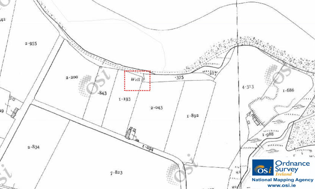
Well marked on historic 25-inch map. © Ordnance Survey Ireland/Government of Ireland.12
On the west side of Estuary road, the maps indicate an ‘Old Mill Race’ but no trace of it remains. An 1851 map shows a canal running from the mill race along Old Yellow Walls road, marked as “Canal and Half Road”.5

Old Mill Race, mid-19th Century. © Ordnance Survey Ireland/Government of Ireland.7
The Yellow Walls’ parish church (RC) is the ‘Sacred Heart’ (Yellow Walls’ parish was constituted from St. Sylvester’s, Malahide in 1996) and it is also located on Estuary road, as is Saint Benedict’s, a communal living scheme for senior citizens.
About 100 metres inside the entrance to the Killeen estate stood a house called “Green Meadow”, described in an 1836 Ordnance Survey as “a ground floor thatched cottage in bad repair. There is a lawn in front of the house in which are a few ornamental trees.”10
Killeen itself is named after Killeen Terrace in Malahide village, built in 1835 by John Killeen, who was also instrumental in the building of the railway viaduct across the Broadmeadow estuary.
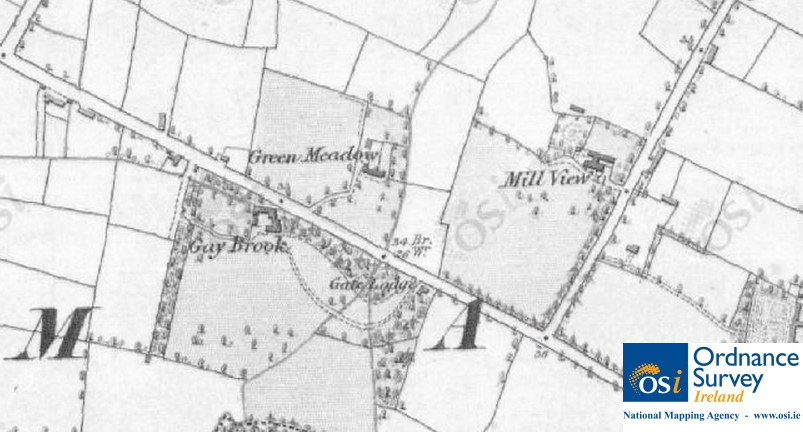
Green Meadow and Gay Brook houses shown on OSI Historic 6″ Map of Yellow Walls (completed between 1829 and 1842). © Ordnance Survey Ireland/Government of Ireland.7
Across the road, in what is now the Talbot estate, stood Gaybrook House, after the stream of the same name. This was once the home of the Rev. F. Chamley, after whom nearby Chamley Park is named. It is described in the 1836 Ordnance Survey as a “neat 2 story slated house in good repair and pleasantly situated. The demesne contains 14 3/4 acres.”10 The house was demolished in 1959. Further along the Malahide-Swords road towards Malahide Demesne, we have Gaybrook Lawns.
Gainsborough is named after the sinking of the ship of the same name in 1838.
The construction dates of the residential areas in Yellow Walls are shown below.
| Estate | Build Date |
| Castleview Park | 1929 |
| Ard Na Mara | 1963 |
| Inbhir Ide | 1966 |
| Gaybrook Lawns | 1970 |
| Sonesta | 1972 |
| Millview | 1973 |
| The Cove | 1975 |
| Oakleigh Court | 1976 |
| Seabury | 1983 |
| Talbot Court | 1989 |
| The Warren | 1992 |
| Killeen | 1993 |
| Milford | 1993 |
| Gainsborough | 1999 |
| Castleheath | 2003 |
| Estuary Walk | 2003 |
| Lissadel Wood | 2004 |
| Chamley Park | 2005 |
| Old Estuary Mill | 2006 |
| Clounties Court | 2006 |
| Chamley Gardens | 2009 |
| Dunard | 2014 |
| Whitegables | 2016 |
†The first complete ordnance survey of Ireland took place between 1829 and 1842 and resulted in a series of maps at a scale of 6 inches to one mile (referred to as Historic 6″ on the OSI map viewer). A second survey was completed between 1887 and 1913 resulting in a series of maps at a scale of 25 inches to one mile (referred to as Historic 25″ on the OSI map viewer).
*Many of the fields in Yellow Walls had names that are no longer in everyday use. Names could be derived from various sources including the field’s topography (its form and features), the landowner, the purpose of the field, or some event that took place there. Some of these old names can be viewed at the Fingal Fieldnames Project website.11
Sources
1. Irish Independent, May 16, 1963.
2. Ordnance Survey Of Ireland, 2011, Public Map Viewer [online].
3. Irish Independent, Jan 20, 1984.
4. Aalen, F. H. Man and the Landscape in Ireland , Academic Press, 1978.
5. Survey of the Town and Lands of Malahide. Clarges Greene & Son, 1851.
6. D’Alton, John. The History of the County of Dublin. Hodges and Smith, 1838.
7. Ordnance Survey Of Ireland 6″ Map: [online]. Reproduced under licence from Ordnance Survey of Ireland; Licence No. NE 0000414.
8. Irish Times, October 29, 1929.
9. Irish Times, December 5, 1959.
10. Ordnance Survey Field Name Book: Malahide, County Dublin, 1836.
11. Fingal Fieldnames Project. [online].
12. Ordnance Survey Of Ireland 25″ Map: [online]. Reproduced under licence from Ordnance Survey of Ireland; Licence No. NE 0000414.

