“The portion of the townland of Yellow Walls, in the parish of Malahide, which is bounded by the Malahide Strand or Estuary on the north, by Seatown East and Drinan on the west, and on the south and east by an imaginary line commencing at the western boundary of the said townland of Yellow Walls…”1

19th Century Map showing Yellow Walls*
Y
ellow Walls is one of more than 60,000 ‘townlands’ in Ireland. A townland is an area comprising anywhere between less than an acre and several thousand acres. Historically the territorial divisions in Ireland are counties first and largest, followed in descending size by baronies, parishes and townlands, with townlands being the unit division. In cities and large towns division is by parishes and streets, with the latter being the unit division.2
The origins of a townland name usually refer to a prominent landmark in the local area such as a village, church, fort or wood3, or in the case of Yellow Walls, possibly to a local industry carried on there.
While some townlands were created after the Norman invasion of 1169, the majority have names derived from the Irish language, indicating more ancient origins.
The boundaries of townlands in Ireland were surveyed and recorded by the Ordnance Survey of Ireland in the 1830s. Maps from the period show the names, shapes and sizes of all of the country’s townlands. Nineteenth century maps4† show the townland of Yellow Walls encompassing about 405 acres. An extract5 from the map below shows the figure ‘405’ under the letter ‘A’ which stands for ‘acres’. The other letters ‘R’ and ‘P’ stand for ‘roods’ and ‘perches’, respectively. A rood is 1/4 of an acre, while a perch is 1/40th of a rood.6
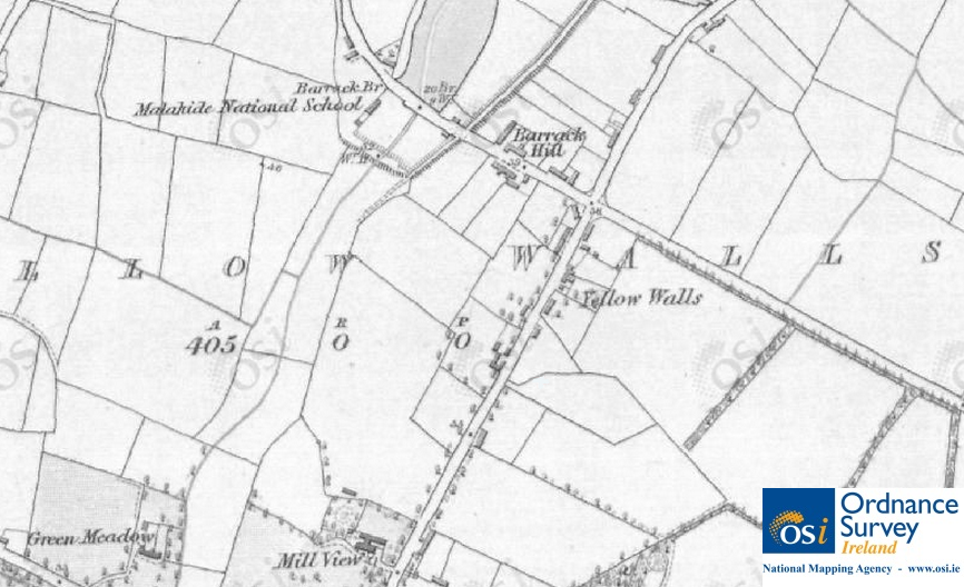
Extract from 6″ OSI Map of Yellow Walls. © Ordnance Survey Ireland/Government of Ireland.5
The boundaries of the Yellow Walls townland are shown in the maps below.
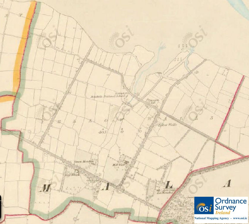
Townland of Yellow Walls shown in 6″ OSI map, mid-19th Century. © Ordnance Survey Ireland/Government of Ireland.5

Townland of Yellow Walls (Modern)
An 1836 Ordnance Survey7 provides the following description of Yellow Walls:
The property of Lord Talbot. Contains 404 A (acres), 3 R (roods), 39.854 P (perches) (besides 2 islands 2 A, 0 R, 7 P in extent) including 21 3/4 acres of Demesne and 4 1/2 acres of Plantation not in the Demesne.
The highest rents are £6 – leases for 21 and 31 years. The farm produce is wheat, oats, barley and potatoes. The townland is closely intercepted by roads which are kept in good repair. In the S (south) part of the townland on the S side of the road from Swords to Malahide is Gay Brook house and on the N side are Green Meadow, Millview and La Mancha houses.
In the N part is a National School, the average attendance is 45 all males of the Protestant religion – it is supported by subscriptions and by the Board of Education.
Other townlands bordering Yellow Walls include Auburn, Drinan, Malahide Demesne (which includes Malahide Castle), and Malahide itself.
*This map can be accessed at the UCD Digital Library and is entitled “Map of the Environs of Dublin, / Drawn and Engraved under the Superintendence of the Society for the Diffusion of Useful Knowledge”.
†The first complete ordnance survey of Ireland took place between 1829 and 1842 and resulted in a series of maps at a scale of 6 inches to one mile (referred to as Historic 6″ on the OSI map viewer). A second survey was completed between 1887 and 1913 resulting in a series of maps at a scale of 25 inches to one mile (referred to as Historic 25″ on the OSI map viewer).
Sources
1. Parliamentary Notices, The Freeman’s Journal, November 15 1872.
2. Twelfth General Report from the Church Estates Commissioners; with an Appendix. 1863.
3. Mitchell, Brian. A new genealogical atlas of Ireland. Genealogical Publishing Company, 2002.
4. Ordnance Survey Of Ireland, Public Map Viewer [online].
5. Ordnance Survey Of Ireland 6″ Map [online]. Reproduced under licence from Ordnance Survey of Ireland; Licence No. NE 0000414.
6. Pedder, James. The farmer’s land-measurer: or, Pocket companion, showing at one view, the content of any piece of land from dimensions taken in yards; with a set of useful agricultural tables, 1853.
7. Ordnance Survey Field Name Book: Malahide, County Dublin, 1836.

